 |
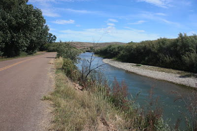
| Missouri River at Ulm, MT facing east. |
I love maps.
I love to ponder routes to take on maps.
I love finding out of the way places to drive on maps.
The trouble with maps is that the length of time it takes to drive a route
might be much more than you think!
I had planned a very ambitious drive for today.
Too ambitious probably.
It's a good thing I zigged when I should have zagged and cut the route by 2/3's!
 |
| Missouri River at Ulm facing west |
At any rate, we headed north on I-15 towards Grand Rapids.
Got off the highway at Wolf Creek.
(Have you ever noticed how many places have the same name?)
Drove along the Missouri River for a good long ways.
Between Wolf Creek and Cascade you are nearly always right on the river.
All along are cabins and small resorts and fishermen.
Fishermen in waders,
Fishermen in canoes,
In Kayaks,
In Boats,
Everyone in a boat just letting the current take them along while they fish.
Occasionally using an oar to keep from getting grounded.
When you get to Cascade the land changes to the flat(ish) and you don't see the river as much.
You know it's there
There are river access signs everywhere!
At Ulm we headed back south, intending to drive the Smith River valley way to the south.
 |
| Smith River |
 |
| Also the Smith river. |
Sometimes I couldn't see the river but I could always see the fields being irrigated by it!
They were really green!
Once away from the river you are in cattle country.
So, I knew we would be on gravel road at least part of the time and instead of staying on the "paved" road I went straight ahead on the gravel.
What can I say, the map has road names
the road does not have street signs.
We went up a very tall bluff and at the top was this.
So we drove on.
Taking a chance on another gravel road
only because it seemed to have the most traffic.
We went through beautiful, isolated ranches.
I don't know how many miles we drove,
Not terribly far I don't think but we only saw two houses.
 |
| Big Belt Mountains-we would drive through them on the way back |
 |
| Mountains to the north-you can sort of see Sleeping Giant even though it doesn't much look like one from here. |
At the end of the gravel road,
we cam to
Cascade.
Where we got back on I-15 southbound this time
and returned to Helena.
Gone about 4 hours.
See why I think it's good I zigged!
Tomorrow, is our day to tidy up, do laundry, etc
so I doubt we leave the campground.
Quinn needs a bath
after which
I will need a bath
as will the trailer!
Tuesday, we're off to Butte!


1 comment:
I agree, maps can be quite deceiving but it is fun to drive around and take the *road less travelled*. The photos are stunning - such wonderful country. I could sit on the riverbank with a line in the water waiting for a bite.
Post a Comment