So, now that you been told all the fun stuff in Utah how about you hear what's happened since?
I left Cedar City, UT in the morning wearing a shirt and warm sweater as it was 30 degrees. My hands took a long time getting warm from hooking up! Hit the Interstate headed for Las Vegas, NV.
The only remarkable thing about that is the Virgin River Canyon which is actually in Arizona.
I think I might have mentioned, once or twice, my aversion to pulling the trailer in heavy wind. There wasn't a big wind on moving day but there were all these signs about heavy crosswinds in the canyon-anticipation can be exhausting! In Nevada there are mountains, all around. Nearly bare of vegetation and only scrub in the valleys between. One thing though, without vegetation the layers of sedimentary rock are quite visible and they are all at an angle from Tectonic plate shifts.
I really try to find things that are interesting but it's a challenge in the desert!
We arrive in Las Vegas in the early afternoon, our campground just to the south of Nellis Air Force base and the Thunderbirds are practicing which reminded me of Larry and all the open houses on the bases where he was stationed. One thing about being near an AF base is that it is really noisy during the day! But very quiet on the weekends and at night-one or two planes might land or take off but it you hear a lot of planes being scrambled you'd better get up and see what's happening! It was 80 degrees, we hadn't seen 80 degrees in a really long time! Quinn is not happy!
I'm not a gambler-not opposed to it necessarily, I just find it boring-so the three days were spent finding dog parks (to run those little sheltie legs) and quilt shops. The campground had a dog washing station so Quinn got a bath and a good brushing before we headed out on the next leg of the trip.
We left Las Vegas Sunday morning at 9:30am. I got on the interstate and stayed in the right hand lane as I'm slower than the cars. I never changed lanes but when we got out of Vegas I was in the far LEFT-HAND lane! Traffic was horrible-all the way to Yerma, CA where we are parked now. Nothing to do here except read, do laundry etc until we move to San Diego on Wednesday.
Monday, October 10, 2016

Sunday, October 9, 2016
Parowan Gap

For our last outing in Utah we did something different.
We drove out into the flat (mostly) to Parowan Gap to see the petroglyphs.
The gap between the two sides at one point had a river running through it
and was used by early peoples as a traveling aid.
As well as a meeting place - apparently much visiting between groups.
The rocks on the sides of the gap are covered with petroglyphs.
They have been documented and studied-it seems pretty extensively.
One person studied them as cryptology and felt that they were symbols for sign language
that a great many groups understood.
There are other petroglyphs that share the same markings in other areas, so that makes some sense.
The markings here are thought to have been made by a farming group called the Fremonts
about 500AD.
Both modern day Utes and Hopis claim some relationship to the Fremonts.
Anyway, on to the Petroglyphs!

This is called the zipper.
One scientist believes it to be an astrological symbol relating to the many Cairns found in the surrounding area.
Plus on the summer solstice the sun rises directly in the middle of the gap.
You can read much more detailed description here.


See the Alien under the round spot?
Personally, I think it looks like one of the Hopi Kachinas.
I took 57 photos at the gap-there were petroglyphs everywhere.
I don't know maybe we're all making too much of it and it was just bored children writing on the wall.
Saturday, October 8, 2016
Cedar Breaks

After we left Bryce Canyon we went back along Rte 12 to US 89.
Oh yeah, had lunch-fried chicken and cherry pie!
Turned left and drove up to Utah 143, or perhaps it was a county road who knows?
Many signs on this paved road about how it wasn't suitable for vehicles over a certain weight or length.
I don't really know how long or how much weight my truck carries but I was pretty sure they meant bigger than a pickup!
The one that would worry me the most was the "No snowplowing after dark" and one that left me feeling like they might not get around to plowing at all!
Happily, it was a beautiful day and no flakes fell from the sky!
We drove past beautiful mountain lakes, without a single waterfowl in sight.
Hum, guess they've all gone south for the winter.
Through wide meadows.
Beside Aspen grove.
Beside more of the Black Rock Desert.
Through a very large flock of sheep-on both sides of the road,
sometimes ON the road-wonder when they bring them down from the high country
Some cattle still up there as well.
Again you don't feel as if you are doing any real climbing
but in the back of your mind is still that very large hill you drove up!
Knowing at some point you really have to go down.
You turn into Cedar Breaks Monument and drive some more
without really seeing anything but trees.
Finally, there's a pull off.
And walking out you see what is called The Amphitheater.
Bowl shaped.

The two photos are of the amphitheater.
Then you go on to the Visitor's Center.
By this time I'd driven more miles than I wanted to think about,
was so tired I really didn't care
and still had that big hill to go down!
On the way down that hill I saw the breaks from the bottom!
No place to stop and take a picture-dang it!
I have on more than one occasion this trip wished for a Dash-Cam!
I see amazing things and don't have the opportunity to take pictures.
Finally, we arrived back in Cedar City.
Fell into bed about 8pm!
Friday, October 7, 2016
Bryce Canyon National Park
 |
| One of the lower rock formations and one of the few not quite red. |
When you drive into Bryce Canyon Park you're just driving through a nice forest.
Some tree tunnels, pretty aspen
some meadows, some deer
(including one who got my heart rate up by walking out onto the road in front of me!)
The road goes a bit twisty and does some up and down.
Occasionally, off to the left you see a lot of space.
In the end though you really have gone up!
Clear up to 9115 ft by the time you get to the Rainbow overlook at the end.
I'd been told by the folks at the campground that when I got to Bryce I should drive
to the end of the road without stopping at any of the overlooks.
That way I wouldn't have to cross traffic as they were all on one side.
I didn't have that much traffic to worry about but I'm glad I did it that way.
Because, when you park at Rainbow overlook
and walk up the the edge
this is what you see!
(The next five photos are a right to left progression of what I saw.)

The first time I saw the Grand Canyon
it took my breath away.
So did Bryce!
Bryce isn't quite as mystical as the Grand Canyon
but you can see forever.
I thought I could see part of the Grand Staircase at Escalante National Monument!


Can you see the road far off in the distance?
Of course, I stood there wondering where it went and if I'd need four wheel drive!


Just so you know how far down is!
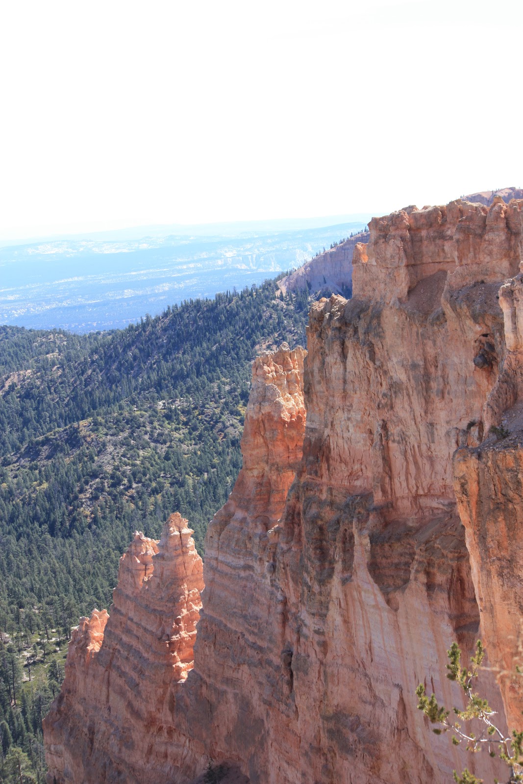

There are hiking trails, horse trails and a bike trail!
I wish I could have seen these from the bottom as well as the top!
I'm of the opinion that it would require weeks (or longer) to really SEE
this part of the country!
And a Jeep!
Thursday, October 6, 2016
Red Canyon

I know I said I was going to do Bryce Canyon today but I'm still pondering which pictures to use! I took quite a few!
Anyway, beginning where I left off yesterday. Utah 14 ends at US 89 so, following the signs, we turned North and drove through a wide and pretty valley. We never did come down from the mountain just hit a plateau. Then you turn onto highway 12 towards Bryce Canyon.
Before you arrive at Bryce you pass through Red Canyon. A part of Dixie National Forest and a Forest Service site. The road also passed through three tunnels in the red rock.

The Forest Service has a nice Visitor's Center there (first Forest Service center I've seen but they likely have others.) Quinn and I stretched our legs before Bryce. I think I ditched my winter coat here! It was cold!

Wednesday, October 5, 2016
Driving East

Yesterday, Quinn and I got up early (for us) and headed east for Bryce Canyon National Park.
It was a long day.
I was very tired when we got back.
So no blog post.
There is so much to say about this trip that I'm going to divided it into three blogs over
the next three days.
Then I'll catch up on the rest of the happenings!
So.
Into downtown Cedar City
turn left
go by the grade school
head up the mountain!
Way up.
Stopped at one pull out
to attempt cleaning the inside of the window so I could see!
This was the view.
Amazing, huh?
Looking south toward Zion National Park on the far right.
The informative signage said that Zion was about 80 miles away.
That big rock in the middle was 76 miles away.
You can see for a long way in the desert!
Remember that!
Once we reached the top of the mountain we drove most of the rest of the way
through wide meadows bordered with spruce and aspen trees.
This high the aspen had already lost their leaves
While in Cedar City they are just beginning to leave green behind.
Just before we got to Duck Creek
I began noticing large areas of ground that looked like it had been plowed.
As I went further along I realized that it looked like a lava flow.
When I got back I looked it up!
The Markagunt Plateau Volcano
You can read more about it here-
It covers about 800 sq miles of the Colorado Plateau region and is called the
Black Rock Desert.
Speaking of the Colorado Plateau-
There are 22 National Parks and National Monuments on the Plateau.
5 National Parks are in Utah along with 3 National Monuments.
In Utah-I've been to 1 National park and 2 National Monuments.
On the Colorado Plateau I've been to
4 National Parks and 2 National Monuments.
I have a ways to go before I see them all!
Tomorrow, will be all about Bryce Canyon National Park!
Monday, October 3, 2016
Onward through Utah!

I'm sure that lots of people would disagree but I thinks its ugly. At least the part from Salt Lake to Cedar City. I took all of these from a rest area -although what the State of Utah considers a rest area is in fact a paved lot next to a gas station, not even a place for Quinn to potty!
This the the Great Basin. It goes West thorough Utah and Nevada and ends with the Sierras in California. For trail travelers during the Gold Rush of the 1800's it is the most difficult stretch. The trail follows the Humboldt River until it just disappears! Then there is no water for a very long distance, heavy sand, no feed, tired animals and people. This is one of the places the Donner party had difficulty and because of them the State of California sent out rescue parties each fall and eventually built places along the trail with feed, and water.


Today, I hit the Quilt shop-came away empty handed - and Walmart, out of TP! Did the laundry (I still need to remake the bed, sigh), then Quinn and I took a walk along the river in the wind, again.
Tomorrow, we are going to Brice Canyon so I hope to have some better pictures! I also hope it's pretty enough to begin to redeem Utah!
Subscribe to:
Posts (Atom)